In 2018, the Ekuanitshit Innu community, in partnership with the First Nations of Quebec and Labrador Sustainable Development Institute (FNQLSDI), launched a project to restore and protect the coastal habitats along the traditional territory of Nitassinan.

The coastal stabilization project, entitled “Preserving the Coastal Habitats of Nitassinan” and created in 2016, stems from targeted activities in the Ekuanitshit community’s Climate Change Adaptation Plan. This project addresses the concerns of its members regarding the erosion of the banks of the St. Lawrence River. Actually, coastal erosion threatens the community’s infrastructure, leads to losses of territory and has an impact on activities taking place along the shoreline. Moreover, this phenomenon is intensifying as a result of climate change.

Preserving the coastal habitats of Nitassinan

Initiated in 2018, the project spans three years and its main objective is to the restore the sites degraded by coastal erosion and which community members deem to be priorities. The project was made possible through the financial contribution of the Community Interaction Program (CIP) under the 2011‒2026 St. Lawrence Action Plan.

The project also includes community mobilization activities, awareness workshops, a best practices guide for coastal environments (now available in French and soon in Innu), awareness panels and a data update on the coastal changes of the Nitassinan. These activities are carried out in collaboration with the Council of the Innu of Ekuanitshit, the Kanikaniteht Business Centre, the Innu House of Culture, the Gulf North Shore Zip Committee, the Youth Centre, the Teueikan School, Innu Natukuna and the Laboratoire de dynamique et de gestion intégrée des zones côtières (dynamics and integrated management of coastal areas laboratory) of the University of Quebec in Rimouski.

With the support of community members, the first year of the project focused on the identification and characterization of the priority sites to be restored. Two so-called soft techniques were chosen for the restoration:
– Revegetation: this technique involves planting native stabilizing plants along the river so that their roots will retain sand;
– Sand catchers: owing to the installation of snow fences set up in a zig-zag pattern, this technique makes it possible to rebuild damaged dunes by creating an accumulation of sand at their base.

Summer 2019 was spent restoring selected sites, one of which is in front the Innu House of Culture, and another is located in the western end of the community. To accomplish this, 80-meter sand catchers were installed and an area of 4,100 square meters was revegetated through the planting of 50,000 sand ryegrass and ammophilia plants. Plants used in traditional practices, such as raspberry and juniper, were also planted in collaboration with Innu Natukuna.

Monitoring the restored sites will begin this fall and will be spread out over a year in order to maximize the viability of the habitats. Mobilization and awareness activities with community members (from children to seniors) will also continue until the end of the project.

We thank the community members who have supported the restoration work, in one way or another, and also we thank the Gulf North Shore ZIP Committee for their technical support!

Some measures to protect coastal habitats

As the saying goes, “An ounce of prevention is worth a pound of cure!” So, taking care of the coast is the best way to prevent coastal erosion.

So, here are some eco-responsible actions that each one of us can adopt:
– Walking or riding on access trails;
– On the shore, walking or riding as close as possible to the water;
– Being mindful of plants by avoiding stepping on them;
– Always taking our garbage to specified locations.

We are responsible for acting right now to preserve and sustain our land. The ball is in your court!

Des plantes pour limiter l’érosion côtière à Ekuanitshit

La communauté innue d’Ekuanitshit, en partenariat avec l’Institut de développement durable des Premières Nations du Québec et du Labrador (IDDPNQL), a amorcé en 2018 un projet de restauration et de protection des habitats côtiers qui longent le territoire traditionnel, le Nitassinan.

Le projet de stabilisation côtière, intitulé « Préserver les habitats littoraux du Nitassinan » et créé en 2016, découle des activités ciblées dans le plan d’adaptation aux changements climatiques de la communauté d’Ekuanitshit. Ce projet répond aux inquiétudes de ses membres face à l’érosion des berges du Saint-Laurent. En effet, l’érosion côtière menace les infrastructures de la communauté, entraine des pertes de territoire et affecte les activités pratiquées le long de la côte. De plus, ce phénomène tend à s’intensifier avec les changements climatiques.

Préserver les habitats littoraux du Nitassinan

Initié en 2018, le projet s’étale sur trois ans et a comme objectif principal de restaurer des sites dégradés par l’érosion côtière et jugés comme prioritaires par les membres de la communauté. Il a été rendu possible grâce à la contribution financière du programme Interactions communautaires (PIC) dans le cadre du Plan d’action Saint-Laurent 2011-2026.

Ce projet inclut également des activités de mobilisation communautaire, des ateliers de sensibilisation, un guide des bonnes pratiques en milieu côtier (actuellement disponible en français et prochainement en innu), des panneaux de sensibilisation et une mise à jour des données sur l’évolution côtière du Nitassinan. Ces activités sont réalisées en collaboration avec le Conseil des Innus de Ekuanitshit, le Centre d’affaires Kanikaniteht, la Maison de la culture Innue, le Comité ZIP Côte-Nord du Golfe, la Maison des jeunes, l’école Teueikan, Innu Natukuna et le laboratoire de dynamique et de gestion intégrée des zones côtières de l’Université du Québec à Rimouski.

Avec le soutien des membres de la communauté, la première année du projet s’est focalisée sur l’identification et la caractérisation des sites à restaurer en priorité. Deux techniques dites douces ont été retenues pour la restauration :
– La végétalisation : cette technique consiste à planter des plantes stabilisatrices indigènes le long de la rive pour retenir le sable grâce aux racines des plantes;
– Les capteurs de sable : grâce à la pose de clôtures à neige disposées en zigzag, cette technique permet de reconstituer les dunes endommagées en provoquant l’accumulation de sable à leur base.

L’été 2019 a été consacré à la restauration des sites sélectionnés dont un devant la Maison de la culture Innue et un autre à l’ouest de la communauté. Pour cela, des capteurs de sable d’une longueur de 80 mètres ont été installés et une superficie de 4 100 mètres carrés a été végétalisée par la plantation de 50 000 plants d’élyme des sables et d’ammophiles à ligule courte. Des plantes servant aux pratiques traditionnelles, comme le framboisier et le genévrier, furent également semées en collaboration avec Innu Natukuna.

Un suivi des sites restaurés commencera cet automne et s’étalera sur un an afin de maximiser les chances de survie des habitats. Les activités de mobilisation et de sensibilisation auprès des membres de la communauté (des enfants aux ainés) se poursuivront également jusqu’à la fin du projet.

Merci aux membres de la communauté qui ont soutenu, d’une manière ou d’une autre, les travaux de restauration ainsi qu’au Comité ZIP Côte-Nord du Golfe pour leur appui technique!

Quelques mesures pour protéger les habitats côtiers

Comme le dit si bien le dicton : mieux vaut prévenir que guérir! Ainsi, prendre soin de la côte est le meilleur moyen de lutter contre l’érosion côtière.

Voici donc quelques gestes écoresponsables qui peuvent être adoptés par chacun d’entre nous :
– Marcher ou rouler dans les sentiers d’accès;
– Sur la plage, marcher ou rouler le plus près possible de l’eau;
– Respecter les plantes en évitant leur piétinement;
– Toujours ramener vos déchets aux endroits prévus.

Il est de notre devoir d’agir dès maintenant pour préserver et pérenniser le territoire. À vous de jouer!

Article Source: Institut de développement durable des Premières Nations du Québec et du Labrador
First Nations of Quebec and Labrador Sustainable Development Institute

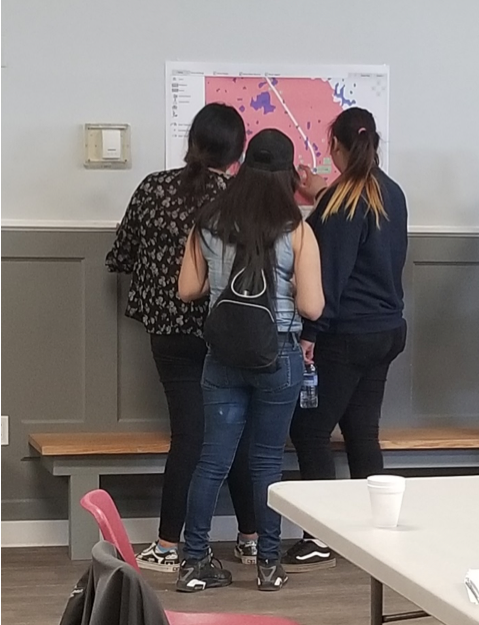
Researchers and Community looking at maps of flooding events

(Image: Researchers and community members looking at maps of flooding events in YQFN)

Introduction:

Being no stranger to threats from climate change through growing up with constant flooding, forest fires, and extreme weather overwhelming his community, Myron Neapetung, a Councilor at Yellow Quill First Nation, had an idea to help his community be better prepared for the future. Over the years, he had built relationships with the University of Saskatchewan, and felt like it was time to start gathering the Elders’ stories and working with scientists on climate change concerns so that ongoing problems could finally be resolved. In May 2018, together with Lori Bradford, an Assistant Professor in the School of Environment and Sustainability at the University of Saskatchewan, Myron launched a First Nations Adapt Program grant to look at their community’s vulnerability to more frequent flooding brought on by the effects of the climate emergency.

The project had four main parts. Looking back through records at the Band office, and the urban services office in Saskatoon, Myron realized that the community was short on record keeping and mapping capacities, so the first step was to contract LiDAR services (Light Detection and Ranging, a remote sensing method that uses a pulsed laser to measure ranges) for the entire watershed. With this very detailed information about the elevation of the land around the reserve, computer modelers at the University of Saskatchewan were able to put together risk maps and put these maps into models that predict flooding. The community was presented with maps that showed where water would likely go if there were a variety of storms, like 50- and 100mm flooding events. Elders and knowledge holders in the community verified these maps to help the computer modelers improve their accuracy. With a shortage of LIDAR available in Saskatchewan, the University-based modelers were very grateful to be involved in this work and learning from those experiencing flooding was incredibly valuable to them.

Picture 1: LIDAR DEM Map showing elevation

lidar map

The second step involved bringing people, young and old, from the community together to talk about flooding. That involved many community meetings in the summer of 2018, interviews with Elders and knowledge holders, projects with school students, and sharing circles. We also used a variety of other data gathering techniques like drawing and taking pictures of flood effects, going on extensive community tours, hosting poster sessions for feedback on any information gathered already, and enjoying many community lunches together. Myron, University students, and the researchers then analyzed the combined data from these activities and made posters and presentations to share with the community and other researchers at conferences.

Picture 2: Community meeting with posters

Community meeting with posters

The third step involved hiring three summer students in the community to look at the emergency management planning documents, and talk with emergency personnel, such as firefighters, road crews, water treatment officers, Chief and Council members, health care workers, wellness center staff, and others involved during emergencies. These students catalogued everyone’s ideas to improve emergency plans in the case of flooding. The three summer students are in the middle of summarizing their results and comparing them to what is written in the official documents.

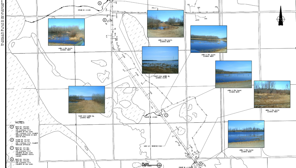
Picture 3: Photo of records of previous work on flood engineering

Flood engineering

The last step for the vulnerability assessment was to invite some engineering experts to do an infrastructure assessment in the community to give a thorough review of important infrastructure that is at risk from ongoing flooding. The First Nation PIEVC Infrastructure Resilience Toolkit process will be occurring August 19-23rd in Yellow Quill with the assistance of the Ontario First Nations Technical Services Cooperative, Stantec Inc., and the Saskatchewan First Nations Technical Services Co-operative.

Picture 4: Where the water will go for certain flood events

Yellow Quill FN Watershed


The overall goal is to learn about the vulnerabilities of Yellow Quill First Nation so informed decisions about how to prepare for a future of unpredictable climate-related challenges can be made in a way that respects community-held knowledge and experience while also harnessing some of the hydrological modelling sciences to predict how climate change might affect daily life. This first climate change adaptation opportunity has spearheaded YQFN’s involvement in a number of research projects around water at the University of Saskatchewan and farther afield in Canada, and has provided a lot of capacity building opportunities for people from Yellow Quill to learn more about climate change, floods, research, and emergency management.


Authors: Myron Neapetung, Yellow Quill First Nation and Lori Bradford, University of Saskatchewan

At Kanaka Bar, preparing for climate change is seen as an important milestone towards the achievement of community’s vision of self-sufficiency.  It is being incorporated in everything that is being done by the community on a day to day basis.  The Traditional Territory of Kanaka Bar is located 14 kilometers south of Lytton, B.C., in the Fraser Canyon. Water plays a critical role in the health of the community. Kanaka Bar has five watersheds: Kwoiek Creek, Morneylun Creek, Nekliptum Creek, Siwash Creek and Four Barrel Creek, all of which support traditional food sources, wildlife and agricultural activities, provide drinking water to the community and hydroelectric power to BC Hydro’s grid.

Over the recent years, many changes have been observed throughout the Traditional Territory. Community members have noticed that wildlife is moving away from the community and travelling further up-mountain, salmon numbers are decreasing and are swimming deeper in the Fraser River in search of cooler temperatures and vegetation growth is changing. As well, consistent rainfall has been replaced by long periods of dry weather and unpredictable storms. These local observations are consistent with scientific predictions of how climate change is likely to affect the region. Although drought has not yet affected the community’s water resources, there is substantial concern that they may be threatened as climate change impacts intensify.

In response to these concerning changes within their Territory, Kanaka Bar has undertaken a Community Vulnerability Assessment to better understand how their environment may continue to change, and how these changes may impact key community values and areas of concern.

Understanding Kanaka Bar’s concerns and priorities was the first step in the Vulnerability Assessment process. Together with environmental professionals from Urban Systems, community members gathered at engagement events to ask questions, and express their concerns about climate change and how it would impact community life and well-being.

After priorities were identified, current and future effects of climate change on these areas were studied. Some anticipated changes that emerged from this research were warmer temperatures year-round; less precipitation in the summer but more in the fall, winter, and spring; less snow; more frequent and intense storms events; changes in water resources; continued stress on the salmon population; changes in the availability of traditional foods; and increased risk of forest fire.

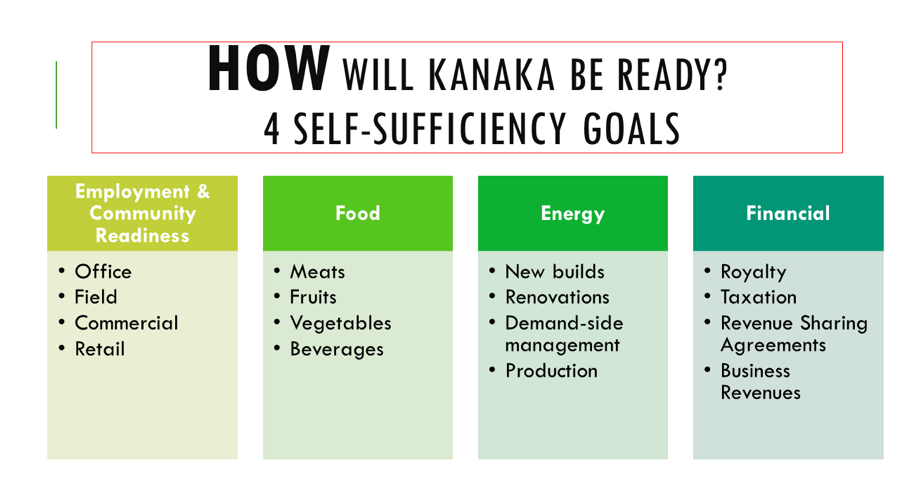
Understanding the ways in which Kanaka Bar was vulnerable to climate change has allowed the community to take meaningful steps towards reducing their risks and becoming more resilient by developing an adaptation strategy. Kanaka Bar’s Adaptation Strategy supports their goal of self-sufficiency while increasing their resilience. It maps out short and long term adaptation actions in six priority areas: Water Resources, Forest Fires, Traditional Foods, Access Roads, Supporting Self-Sufficiency and Youth and Community Engagement and Education. These actions range from installing weather monitoring stations in the community, to expanding food production initiatives, to hosting annual workshops on climate change. Together they represent a “Made at Kanaka, by Kanaka for Kanaka” adaption plan that will benefit the community in a holistic way that goes far beyond coping with climate change.

To learn more about Kanaka Bar and the great strides they’re making towards climate resilience and self-sufficiency, visit their website.

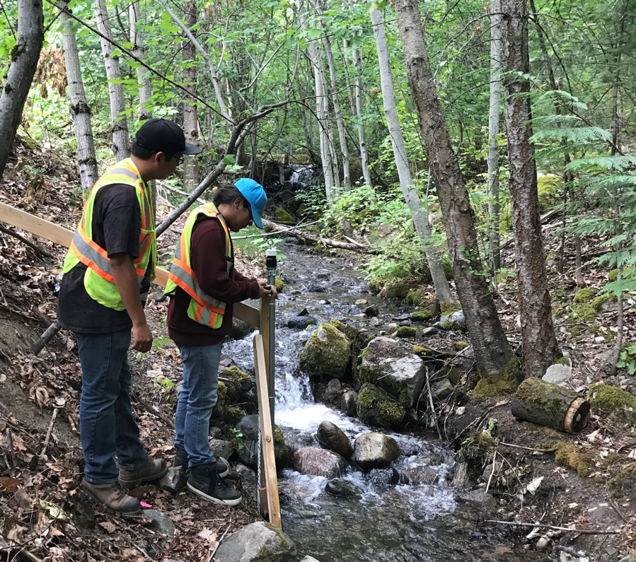
Figure 1Kanaka Youth at Morneylun Water Gauging Station


Author: Kanaka Bar

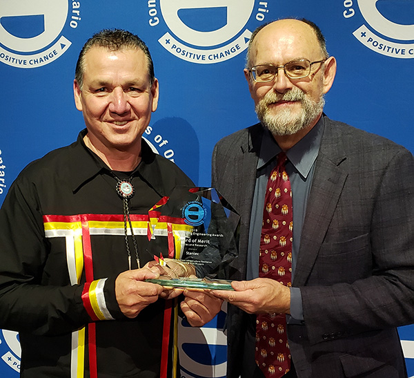
On April 26, 2019, professional service firm Stantec received the Consulting Engineers of Ontario Award for its work developing the First Nations Infrastructure Resilience Toolkit (FN-IRT) in partnership with Ontario First Nations Technical Services Corporation (OFNTSC). The award recognizes the importance and innovative nature of the FN-IRT as a tool that can used by First Nation communities to identify how their infrastructure may be impacted by climate change and develop an asset management plan.

The FN-IRT was adapted from the widely recognized Engineers Canada’s Public Infrastructure Engineering Vulnerability Committee (PIEVC) protocol specifically for use by First Nations communities, many of whom are remote and isolated, and face unique risks from extreme weather, temperature, and precipitation due to climate change. The toolkit works by braiding together engineering information and Indigenous Knowledge to identify potential climate change impacts on a community’s infrastructure. Once these risks are identified, they can be taken into account in decisions regarding the maintenance, repairs, and replacement of roads, bridges, wastewater infrastructure, water treatment facilities, and more.

The FN-IRT is more streamlined than the original PIEVC protocol, making it suitable for use by small or remote First Nations with limited resources. Where First Nation communities may lack historical climate data, lndigenous Knowledge can be used to fill in gaps. Through understanding the risks of climate change to infrastructure, communities will be able to prepare for possible disasters before they happen and recover more quickly when they do occur.

The FN-IRT toolkit has been piloted in three First Nation communities: Mohawk Council of Akwesasne, Oneida Nation of the Thames, and Moose Cree First Nation, where it was used to assess climate change impacts on water and wastewater systems, housing, and schools.  Between 2018 and 2020, Crown-Indigenous Relations and Northern Affairs Canada’s First Nation Adapt program will be funding ten training sessions on applying the toolkit to 200 participants across Ontario.

We congratulate Stantec on their receipt of the Consulting Engineers of Ontario Award and their excellent work designing the toolkit in cooperation with OFNTSC. We look forward to learning how First Nations are applying this valuable tool in their communities.


Photo caption: Elmer Lickers from Ontario First Nations Technical Services (left) and Guy Félio from Stantec (right) receiving the Consulting Engineers of Ontario Award.


Author: OFNTSC

Across the Interlake region in Manitoba, the impacts of a changing climate are being experienced more frequently than in previous years. Compounding this conundrum is the severity of the impacts. Take for example, as a result of severe flooding, several First Nations Communities, who are usually the most affected, were evacuated in 2011 and 2014. Climate colonialism – where the least resilient are shouldered with the responsibility of bearing climate impacts – is another challenge many First Nations communities face. To illustrate, constant water regulation has impacted the Fairford River in Pinaymootang First Nation, a once pristine riparian zone. The flora and fauna have been deeply impacted. “This was once a spawning area for Northern pike. Now, fish cannot be caught by shoreline and rod fishing anymore (rare a fish is caught)”, a community member said.  This change did take not place suddenly, it happened over a period of time – like a slow-moving emergency.

To address some of these issues, Interlake Reserve Tribal Council – a consortium of six First Nations Communities working together to advance the collective wellbeing of its members – utilised a community participatory approach that integrates indigenous knowledge in the process of formulating long term adaptation plans that are unique to each community. First, adaptive capacity measurements and increasing adaptive capacity: Sessions were designed to allow community members to discuss issues and potential solutions and for the project to gather more information. And at treaty days, throughout the summer of 2018, the project had a booth set up (In each community) for further discussions and information sharing. Pre-liminary results indicate that close to 100% of community are aware of climate change and its effect, but are convinced that communities do not have adequate resources in place to tackle these impacts. Second, Community Risk Mapping: Using a participatory approach that integrates traditional knowledge in adaptation planning, climate risks maps were produced. Community members, including leaders, resource users (hunters, fishermen.), and elders, were selected in the various mapping sessions organized. Oral stories and transect walk, in addition to qualitative assessments, were used to identify and assess climate hazards and its level of impact. These data were put on the physical map provided, and later converted into GIS layers.

Third, hazard inventory and risk analysis: Together with IRTC’s emergency management team, the project carried out a preliminary risk analysis of hazards in each community. Stakeholder engagement sessions and site visits to each of the six IRTC First Nations were conducted to acquire local knowledge and context regarding hazards and risks as they applied to individual communities. These engagement sessions included interviews and meetings with Elders and interested community members – all geared towards providing a suitable foundation for adaptation.

As can be seen, IRTC’s project has begun the process of building uniformity of perceptions/views among stakeholders, prioritizing each community’s issues, investing in capacity building, and exploring solutions.  And the one thing, though, that all communities agree on, is that continued action is required combat this slow-moving threat.


Author: Interlake Reserve Tribal Council

We are excited to share the photography and graphic recordings that were taken during the Indigenous Climate Change Adaptation Gathering (ICCAG 2019). A special thanks and Chi Miigwech to Tracey of Tracey Lynne Photography for taking such beautiful images of the gathering. We also wish to thank Jennifer Shepherd of Living Tapestries for capturing the key themes of the gathering in the two graphic recordings.

A Flickr account has been created for the ICCAG 2019 so that gathering participants can access and download the photos. You can find the three albums here:

ICCAG 2019 Albumclick here.

Description: This album contains all of the photos from the gathering, including the sharing circles, presentations, and group sessions. All photos were taken by Tracey Lynne Photography.

Graphic Recordings Albumclick here.

Description: This album contains the 2 graphic recordings (one per day) that were taken on March 18 & 19, 2019 at the ICCAG 2019. Both graphic recordings were created by Jennifer Shepherd of Living Tapestries.

ICCAG 2019 Headshots Albumclick here.

Description: Tracey Lynne Photography kindly offered to take headshot photos for ICCAG 2019 participants. If you had headshot photos taken at the event, you will find them here.