Dealing with the Climate Crisis in Manitoba’s Interlake Region
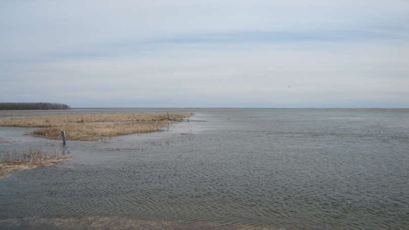
Across the Interlake region in Manitoba, the impacts of a changing climate are being experienced more frequently than in previous years. Compounding this conundrum is the severity of the impacts. Take for example, as a result of severe flooding, several First Nations Communities, who are usually the most affected, were evacuated in 2011 and 2014. Climate colonialism – where the least resilient are shouldered with the responsibility of bearing climate impacts – is another challenge many First Nations communities face. To illustrate, constant water regulation has impacted the Fairford River in Pinaymootang First Nation, a once pristine riparian zone. The flora and fauna have been deeply impacted. “This was once a spawning area for Northern pike. Now, fish cannot be caught by shoreline and rod fishing anymore (rare a fish is caught)”, a community member said. This change did take not place suddenly, it happened over a period of time – like a slow-moving emergency.
To address some of these issues, Interlake Reserve Tribal Council – a consortium of six First Nations Communities working together to advance the collective wellbeing of its members – utilised a community participatory approach that integrates indigenous knowledge in the process of formulating long term adaptation plans that are unique to each community. First, adaptive capacity measurements and increasing adaptive capacity: Sessions were designed to allow community members to discuss issues and potential solutions and for the project to gather more information. And at treaty days, throughout the summer of 2018, the project had a booth set up (In each community) for further discussions and information sharing. Pre-liminary results indicate that close to 100% of community are aware of climate change and its effect, but are convinced that communities do not have adequate resources in place to tackle these impacts. Second, Community Risk Mapping: Using a participatory approach that integrates traditional knowledge in adaptation planning, climate risks maps were produced. Community members, including leaders, resource users (hunters, fishermen.), and elders, were selected in the various mapping sessions organized. Oral stories and transect walk, in addition to qualitative assessments, were used to identify and assess climate hazards and its level of impact. These data were put on the physical map provided, and later converted into GIS layers.
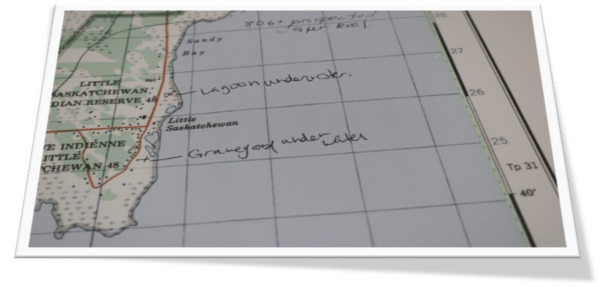
Third, hazard inventory and risk analysis: Together with IRTC’s emergency management team, the project carried out a preliminary risk analysis of hazards in each community. Stakeholder engagement sessions and site visits to each of the six IRTC First Nations were conducted to acquire local knowledge and context regarding hazards and risks as they applied to individual communities. These engagement sessions included interviews and meetings with Elders and interested community members – all geared towards providing a suitable foundation for adaptation.
As can be seen, IRTC’s project has begun the process of building uniformity of perceptions/views among stakeholders, prioritizing each community’s issues, investing in capacity building, and exploring solutions. And the one thing, though, that all communities agree on, is that continued action is required combat this slow-moving threat.
Author: Interlake Reserve Tribal Council
 Gift Lake Métis Settlement
 Bonnie Kittle (Unsplash)
 Envato Elements (Licensed)
 Stephen Walker (Unsplash)
 Drew Farwell (Unsplash)
 Unsplash Community, Licensed
