• Link to X
  • Link to Facebook
  • Link to Instagram
  • Link to Rss this site
Indigenous Climate Hub
  • Home
    • About Us
  • Climate Action Programs
    • First Nation Adapt Program
      • Indigenous Climate Change Adaptation Gatherings
    • Indigenous Community-Based Climate Monitoring Program
    • Climate Change and Health Adaptation Program
    • Climate Change Preparedness in the North
    • Environment and Climate Change Canada
  • Funding
  • Resources
    • Climate Change Directory
    • Resource Library
    • Community Adaptation Projects
  • Events
  • Podcast
  • Blog
  • Contact/FAQs
  • Click to open the search input field Click to open the search input field Search
  • Menu Menu

Preparing for the Future – How Yellow Quill First Nation is using Indigenous knowledge and Science to Mitigate the Risk of Flooding

Climate Change Adaptation, Climate Crisis, Community Engagement, Flooding, Saskatchewan

Researchers and Community looking at maps of flooding events

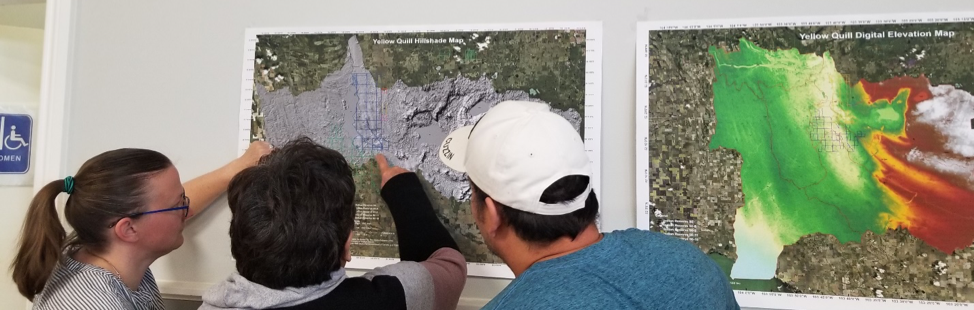
(Image: Researchers and community members looking at maps of flooding events in YQFN)

Introduction:

Being no stranger to threats from climate change through growing up with constant flooding, forest fires, and extreme weather overwhelming his community, Myron Neapetung, a Councilor at Yellow Quill First Nation, had an idea to help his community be better prepared for the future. Over the years, he had built relationships with the University of Saskatchewan, and felt like it was time to start gathering the Elders’ stories and working with scientists on climate change concerns so that ongoing problems could finally be resolved. In May 2018, together with Lori Bradford, an Assistant Professor in the School of Environment and Sustainability at the University of Saskatchewan, Myron launched a First Nations Adapt Program grant to look at their community’s vulnerability to more frequent flooding brought on by the effects of the climate emergency.

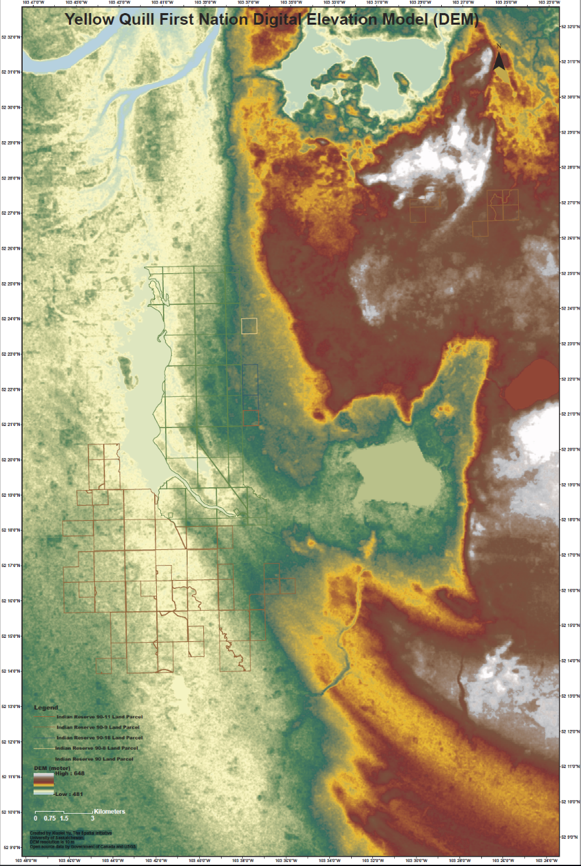
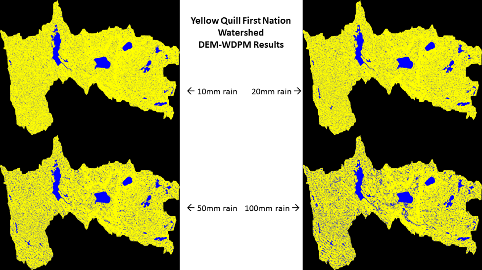
The project had four main parts. Looking back through records at the Band office, and the urban services office in Saskatoon, Myron realized that the community was short on record keeping and mapping capacities, so the first step was to contract LiDAR services (Light Detection and Ranging, a remote sensing method that uses a pulsed laser to measure ranges) for the entire watershed. With this very detailed information about the elevation of the land around the reserve, computer modelers at the University of Saskatchewan were able to put together risk maps and put these maps into models that predict flooding. The community was presented with maps that showed where water would likely go if there were a variety of storms, like 50- and 100mm flooding events. Elders and knowledge holders in the community verified these maps to help the computer modelers improve their accuracy. With a shortage of LIDAR available in Saskatchewan, the University-based modelers were very grateful to be involved in this work and learning from those experiencing flooding was incredibly valuable to them.

Picture 1: LIDAR DEM Map showing elevation

lidar map

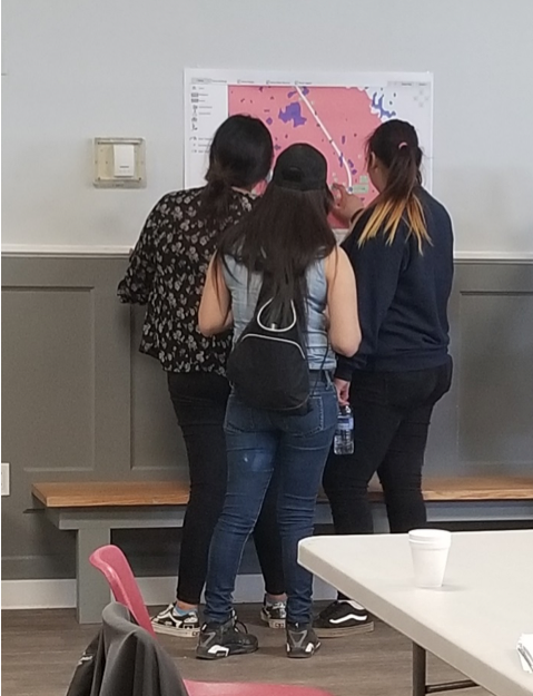
The second step involved bringing people, young and old, from the community together to talk about flooding. That involved many community meetings in the summer of 2018, interviews with Elders and knowledge holders, projects with school students, and sharing circles. We also used a variety of other data gathering techniques like drawing and taking pictures of flood effects, going on extensive community tours, hosting poster sessions for feedback on any information gathered already, and enjoying many community lunches together. Myron, University students, and the researchers then analyzed the combined data from these activities and made posters and presentations to share with the community and other researchers at conferences.

Picture 2: Community meeting with posters

Community meeting with posters

The third step involved hiring three summer students in the community to look at the emergency management planning documents, and talk with emergency personnel, such as firefighters, road crews, water treatment officers, Chief and Council members, health care workers, wellness center staff, and others involved during emergencies. These students catalogued everyone’s ideas to improve emergency plans in the case of flooding. The three summer students are in the middle of summarizing their results and comparing them to what is written in the official documents.

Picture 3: Photo of records of previous work on flood engineering

Flood engineering

The last step for the vulnerability assessment was to invite some engineering experts to do an infrastructure assessment in the community to give a thorough review of important infrastructure that is at risk from ongoing flooding. The First Nation PIEVC Infrastructure Resilience Toolkit process will be occurring August 19-23rd in Yellow Quill with the assistance of the Ontario First Nations Technical Services Cooperative, Stantec Inc., and the Saskatchewan First Nations Technical Services Co-operative.

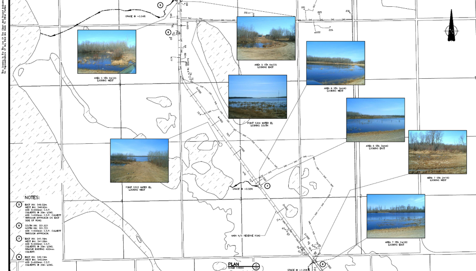
Picture 4: Where the water will go for certain flood events

Yellow Quill FN Watershed


The overall goal is to learn about the vulnerabilities of Yellow Quill First Nation so informed decisions about how to prepare for a future of unpredictable climate-related challenges can be made in a way that respects community-held knowledge and experience while also harnessing some of the hydrological modelling sciences to predict how climate change might affect daily life. This first climate change adaptation opportunity has spearheaded YQFN’s involvement in a number of research projects around water at the University of Saskatchewan and farther afield in Canada, and has provided a lot of capacity building opportunities for people from Yellow Quill to learn more about climate change, floods, research, and emergency management.


Authors: Myron Neapetung, Yellow Quill First Nation and Lori Bradford, University of Saskatchewan

August 12, 2019/by IndigenousClimateHub
Tags: Climate Emergency, Community Engagement, Computer Modeling, Elders and Knowledge Keepers, Emergency Management, Engineering, Extreme Weather, First Nation Adapt Program, Flooding, Infrastructure, LiDAR, Research, Saskatchewan, Science, University of Saskatchewan, Watershed, Yellow Quill First Nation
Share this entry
  • Share on Facebook
  • Share on X
  • Share on WhatsApp
  • Share on Pinterest
  • Share on LinkedIn
  • Share on Tumblr
  • Share on Reddit
  • Share by Mail
https://indigenousclimatehub.ca/wp-content/uploads/2019/08/headerphoto.png 310 974 IndigenousClimateHub https://indigenousclimatehub.ca/wp-content/uploads/2020/10/logo-horiz-clr-01-small-300x88.png IndigenousClimateHub2019-08-12 22:22:232019-08-12 22:23:46Preparing for the Future – How Yellow Quill First Nation is using Indigenous knowledge and Science to Mitigate the Risk of Flooding
You might also like
Alberta Flood Study Engagements: Share your feedback on draft reports and flood maps to help complete the largest flood mapping project in Alberta’s history
Stephen Walker (Unsplash) Adapting to Climate Change through Indigenous-led Watershed Planning
Mi’kmaq Confederacy of Prince Edward Island Supports Communities in Adapting to Climate Change
Dealing with the Climate Crisis in Manitoba’s Interlake Region
Climate Change Adaptation in Kanaka Bar
Solar panels Achieving Net-Zero Carbon Emissions and Energy Sovereignty through Indigenous-Owned Solar Projects
X Logo X Logo Followon X RSS Feed Logo RSS Feed Logo Subscribeto RSS Feed

Subscribe to Our Blog

This field is required.

Check your inbox or spam folder to confirm your subscription.

Recent Posts

  • Water Is a Relative, Not a Resource
  • The River Is Telling Us Something: Indigenous-Led Water Monitoring as Canada’s Climate Early Warning System
  • Night Skies and Shifting Stars: How Indigenous Celestial Knowledge Tracks a Changing Climate
  • From Ownership to Relationship: Reclaiming Our Responsibilities to Land
  • Human Foolishness in Floodplains

Archives

  • June 2026
  • May 2026
  • April 2026
  • March 2026
  • February 2026
  • January 2026
  • December 2025
  • November 2025
  • October 2025
  • September 2025
  • August 2025
  • July 2025
  • June 2025
  • May 2025
  • April 2025
  • March 2025
  • February 2025
  • January 2025
  • December 2024
  • November 2024
  • October 2024
  • September 2024
  • August 2024
  • July 2024
  • June 2024
  • May 2024
  • April 2024
  • March 2024
  • February 2024
  • January 2024
  • December 2023
  • November 2023
  • October 2023
  • September 2023
  • August 2023
  • July 2023
  • June 2023
  • May 2023
  • April 2023
  • March 2023
  • February 2023
  • January 2023
  • December 2022
  • November 2022
  • October 2022
  • September 2022
  • August 2022
  • July 2022
  • June 2022
  • May 2022
  • April 2022
  • March 2022
  • February 2022
  • January 2022
  • December 2021
  • November 2021
  • October 2021
  • September 2021
  • August 2021
  • July 2021
  • June 2021
  • May 2021
  • April 2021
  • March 2021
  • February 2021
  • January 2021
  • December 2020
  • November 2020
  • October 2020
  • September 2020
  • August 2020
  • July 2020
  • June 2020
  • February 2020
  • October 2019
  • August 2019
  • July 2019
  • June 2019
  • May 2019
  • April 2019
  • March 2019

Categories

  • Adaptation
  • Alberta
  • Announcements
  • Arctic
  • Atlantic/NB
  • Awards
  • Blog
  • British Columbia
  • Climate Change
  • Climate Change Adaptation
  • Climate Change Education
  • Climate Change News
  • Climate Change Project
  • Climate Crisis
  • Climate Monitoring
  • Community Engagement
  • Community-Based Environmental Monitoring
  • Documentaries
  • Documentary
  • Events
  • Flooding
  • Food
  • Food Security
  • Food Sovereignty
  • Forest Fires
  • Funding Opportunity
  • ICCAG 2019
  • Indigenous Perspectives
  • Manitoba
  • Media
  • Métis
  • Métis Settlement
  • News
  • Op-Ed
  • Quebec
  • Saskatchewan
  • Technology
  • Video
  • Water
  • Webinars

Tags

Alberta Arctic Arctic Resilience Forum British Columbia Carbon Sequestration Caribou Caribou Recovery CIRNAC Climate Adaptation Climate Change Climate Change Adaptation Climate Resilience Community Engagement Education Environmental Stewardship Environment and Climate Change Canada (ECCC) First Nations Flooding Food Security Food Sovereignty Global Warming Indigenous Indigenous Guardians Toolkit Indigenous Knowledge Indigenous Stewardship Infrastructure Inuit landscape Mental Health Paris Agreement Policy Renewable Energy Research Resilience Science Traditional Ecological Knowledge Traditional Ecological Knowledge (TEK) Traditional Knowledge UNDRIP United Nations United Nations (UN) Webinar Wildfires WWF-Canada Youth
Contact

About Us

The Indigenous Climate Hub is a unique online community of Indigenous climate change leaders that have come together to share their stories and climate change adaptation experiences. The website is the result of the recommendations brought forward by Indigenous peoples at the Indigenous Climate Change Adaptation Gathering in 2018.

Indigenous Climate Hub Podcast

Be a part of the Indigenous Climate Hub Podcast. We are looking for unique perspectives and experiences in environmental stewardship, Indigenous ecological and traditional knowledge, and resource management offer valuable knowledge and teachings that can benefit Indigenous communities across Turtle Island and beyond.

Indigenous-led Initiatives

Are you a program or organization that funds or supports Indigenous Peoples  working on climate change initiatives?  If you would like to provide information to potential recipients here, please reach out to Okwaho so that we can work with you to highlight your program.

© Copyright - Indigenous Climate Hub, 2025-2026
  • Terms of Service
  • Privacy Policy
Link to: Climate Change Adaptation in Kanaka Bar Link to: Climate Change Adaptation in Kanaka Bar Climate Change Adaptation in Kanaka Bar Link to: Plants to Limit Coastal Erosion in Ekuanitshit Link to: Plants to Limit Coastal Erosion in Ekuanitshit Plants to Limit Coastal Erosion in Ekuanitshit
Scroll to top Scroll to top Scroll to top