Posts

A recent study by researchers at the University of Waterloo examines flood risk as a climate change effect and its complex connection to socio-economic and population factors (or “social vulnerability”) in both Indigenous and non-Indigenous communities in Canada. The study concludes that while the percentage of Indigenous and non-Indigenous residences exposed to flood hazards is roughly the same, the numerous challenges facing Indigenous communities, as an impact of land dispossession and colonization, means “the overall risk of Indigenous communities is higher.”

The peer-reviewed study compares “flood risk between Indigenous communities on 985 reserve lands and other Canadian communities across 3701 census subdivisions” and integrates an analysis of “socio-economic, demographic, ethnic, and cultural characteristics.” Eighty-one percent of the Indigenous communities in the study were exposed to flood hazards which would impact either their land and residences or the overall population.

Typically, flood hazards are categorized as primary, secondary, or tertiary. Primary hazards are associated with flooding where there is direct contact with water (e.g., erosion of soil, buildings, and other infrastructure; water damage to buildings; flooding of farmlands resulting in crop loss; human and animal drownings). Secondary flood hazards are the result of the primary hazards and can include toxic pollutants released by garbage and backed-up debris in sewage drains (i.e., the debris being a primary effect), as well as numerous health effects and service disruptions. Tertiary flood hazards are the long-term effects of primary and secondary flood hazards.


By Leela Viswanathan


(Photo credit: Justin Wilkens, Unsplash)

The community of Kahnawà:ke has observed erosion of the natural shoreline over the years, with particularly high-water levels and flooding in 2017. The shoreline and flood levels have also been impacted by interventions in the Great Lakes and the St. Lawrence, including construction of the seaway. With increased variability in weather patterns as a result of climate change, the community has identified a need to plan for rising water levels and shoreline erosion. In the Kahnawà:ke community, erosion & flooding poses a particular threat to houses & properties located directly on the shoreline, but also to fishing & recreation areas and a secondary drinking water inlet pipe location. We proposed to undertake a project that included a shoreline vulnerability assessment with an emphasis on the impact of climate change on shoreline erosion and flooding along the natural shoreline of the St. Lawrence River within the community of Kahnawà:ke.

We partnered with Shoreplan Engineering and with community members to complete the shoreline vulnerability assessment. Shoreplan conducted a technical coastal engineering assessment which included compiling existing data, completing a review of current & historic orthoimagery, conducting site visits to gather & quantify new data, assessing existing erosion control and the proposal of solutions to on-going erosion and flooding. The shoreline vulnerability assessment included both erosion and flood hazard assessments to determine the vulnerability of our community’s shoreline. The erosion hazard assessment allowed us to determine which structures along our shoreline are at risk of erosion in the future. The erosion hazard assessment revealed that the most significant cause of erosion on the studied shoreline was due to wind wave action, particularly at higher water levels. Wake generated by passing ships further contributed to erosion potential. The flood hazard assessment provided flood hazard limits to our community to help direct future development. It was discovered that a 20-year return period west-wind storm occurring at the 100-year water level will cause uprush that will overtop the riverbank and protection structures everywhere along the study area.

In addition to these field activities, we also hired a community member to conduct public awareness campaigns that addressed climate change in general as well as specifically in relation to this project. The hired community member also distributed a survey to land holders within the project study area to gauge impressions of erosion and flooding on land holder’s properties. Lastly, we hosted an open house event to provide additional information and gather input from the community.

A list of proposed options to address erosion and flooding along the shoreline were provided and tailored to specific reaches of the shore. These methods prioritized ‘soft’ solutions while also outlining the key characteristics for successful implementation of more engineered solutions if an individual landholder choses that approach. Among the natural methods it was suggested to use and enhance vegetation species already present on the landscape to reduce the erosive effects of wave action. This could include the implementation of a planting program with the goal of planting more of these local species of vegetation.  Infrastructure solutions discussed included the use of revetments, stacked armour stone walls, bulkheads or seawalls, groynes, breakwaters, and bioengineering alternatives.


Blog post: Mohawk Council of Kahnawà:ke

Researchers and Community looking at maps of flooding events

(Image: Researchers and community members looking at maps of flooding events in YQFN)

Introduction:

Being no stranger to threats from climate change through growing up with constant flooding, forest fires, and extreme weather overwhelming his community, Myron Neapetung, a Councilor at Yellow Quill First Nation, had an idea to help his community be better prepared for the future. Over the years, he had built relationships with the University of Saskatchewan, and felt like it was time to start gathering the Elders’ stories and working with scientists on climate change concerns so that ongoing problems could finally be resolved. In May 2018, together with Lori Bradford, an Assistant Professor in the School of Environment and Sustainability at the University of Saskatchewan, Myron launched a First Nations Adapt Program grant to look at their community’s vulnerability to more frequent flooding brought on by the effects of the climate emergency.

The project had four main parts. Looking back through records at the Band office, and the urban services office in Saskatoon, Myron realized that the community was short on record keeping and mapping capacities, so the first step was to contract LiDAR services (Light Detection and Ranging, a remote sensing method that uses a pulsed laser to measure ranges) for the entire watershed. With this very detailed information about the elevation of the land around the reserve, computer modelers at the University of Saskatchewan were able to put together risk maps and put these maps into models that predict flooding. The community was presented with maps that showed where water would likely go if there were a variety of storms, like 50- and 100mm flooding events. Elders and knowledge holders in the community verified these maps to help the computer modelers improve their accuracy. With a shortage of LIDAR available in Saskatchewan, the University-based modelers were very grateful to be involved in this work and learning from those experiencing flooding was incredibly valuable to them.

Picture 1: LIDAR DEM Map showing elevation

lidar map

The second step involved bringing people, young and old, from the community together to talk about flooding. That involved many community meetings in the summer of 2018, interviews with Elders and knowledge holders, projects with school students, and sharing circles. We also used a variety of other data gathering techniques like drawing and taking pictures of flood effects, going on extensive community tours, hosting poster sessions for feedback on any information gathered already, and enjoying many community lunches together. Myron, University students, and the researchers then analyzed the combined data from these activities and made posters and presentations to share with the community and other researchers at conferences.

Picture 2: Community meeting with posters
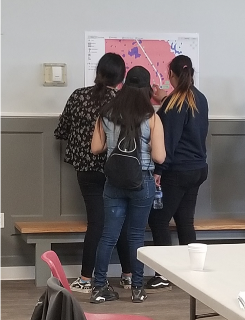
Community meeting with posters

The third step involved hiring three summer students in the community to look at the emergency management planning documents, and talk with emergency personnel, such as firefighters, road crews, water treatment officers, Chief and Council members, health care workers, wellness center staff, and others involved during emergencies. These students catalogued everyone’s ideas to improve emergency plans in the case of flooding. The three summer students are in the middle of summarizing their results and comparing them to what is written in the official documents.

Picture 3: Photo of records of previous work on flood engineering
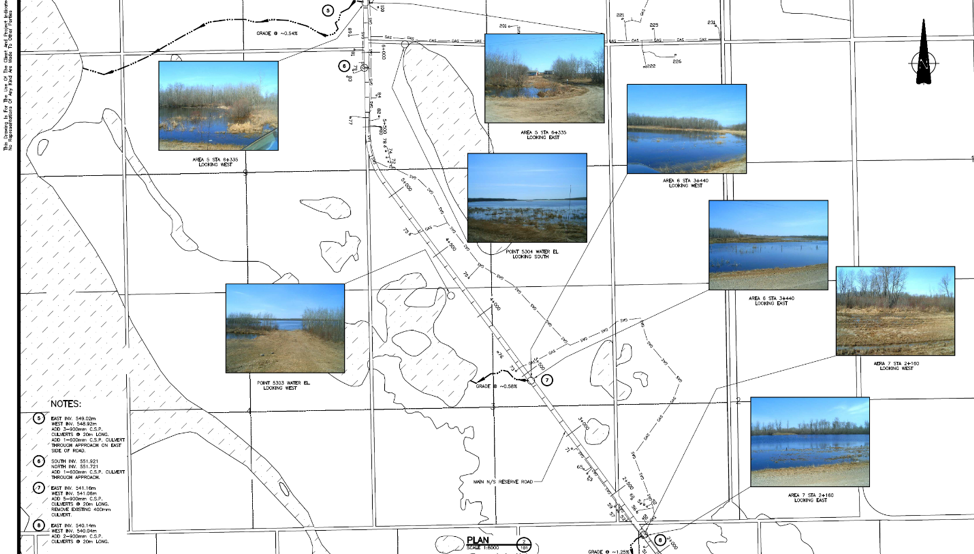
Flood engineering

The last step for the vulnerability assessment was to invite some engineering experts to do an infrastructure assessment in the community to give a thorough review of important infrastructure that is at risk from ongoing flooding. The First Nation PIEVC Infrastructure Resilience Toolkit process will be occurring August 19-23rd in Yellow Quill with the assistance of the Ontario First Nations Technical Services Cooperative, Stantec Inc., and the Saskatchewan First Nations Technical Services Co-operative.

Picture 4: Where the water will go for certain flood events

Yellow Quill FN Watershed


The overall goal is to learn about the vulnerabilities of Yellow Quill First Nation so informed decisions about how to prepare for a future of unpredictable climate-related challenges can be made in a way that respects community-held knowledge and experience while also harnessing some of the hydrological modelling sciences to predict how climate change might affect daily life. This first climate change adaptation opportunity has spearheaded YQFN’s involvement in a number of research projects around water at the University of Saskatchewan and farther afield in Canada, and has provided a lot of capacity building opportunities for people from Yellow Quill to learn more about climate change, floods, research, and emergency management.


Authors: Myron Neapetung, Yellow Quill First Nation and Lori Bradford, University of Saskatchewan

Across the Interlake region in Manitoba, the impacts of a changing climate are being experienced more frequently than in previous years. Compounding this conundrum is the severity of the impacts. Take for example, as a result of severe flooding, several First Nations Communities, who are usually the most affected, were evacuated in 2011 and 2014. Climate colonialism – where the least resilient are shouldered with the responsibility of bearing climate impacts – is another challenge many First Nations communities face. To illustrate, constant water regulation has impacted the Fairford River in Pinaymootang First Nation, a once pristine riparian zone. The flora and fauna have been deeply impacted. “This was once a spawning area for Northern pike. Now, fish cannot be caught by shoreline and rod fishing anymore (rare a fish is caught)”, a community member said.  This change did take not place suddenly, it happened over a period of time – like a slow-moving emergency.

To address some of these issues, Interlake Reserve Tribal Council – a consortium of six First Nations Communities working together to advance the collective wellbeing of its members – utilised a community participatory approach that integrates indigenous knowledge in the process of formulating long term adaptation plans that are unique to each community. First, adaptive capacity measurements and increasing adaptive capacity: Sessions were designed to allow community members to discuss issues and potential solutions and for the project to gather more information. And at treaty days, throughout the summer of 2018, the project had a booth set up (In each community) for further discussions and information sharing. Pre-liminary results indicate that close to 100% of community are aware of climate change and its effect, but are convinced that communities do not have adequate resources in place to tackle these impacts. Second, Community Risk Mapping: Using a participatory approach that integrates traditional knowledge in adaptation planning, climate risks maps were produced. Community members, including leaders, resource users (hunters, fishermen.), and elders, were selected in the various mapping sessions organized. Oral stories and transect walk, in addition to qualitative assessments, were used to identify and assess climate hazards and its level of impact. These data were put on the physical map provided, and later converted into GIS layers.

Third, hazard inventory and risk analysis: Together with IRTC’s emergency management team, the project carried out a preliminary risk analysis of hazards in each community. Stakeholder engagement sessions and site visits to each of the six IRTC First Nations were conducted to acquire local knowledge and context regarding hazards and risks as they applied to individual communities. These engagement sessions included interviews and meetings with Elders and interested community members – all geared towards providing a suitable foundation for adaptation.

As can be seen, IRTC’s project has begun the process of building uniformity of perceptions/views among stakeholders, prioritizing each community’s issues, investing in capacity building, and exploring solutions.  And the one thing, though, that all communities agree on, is that continued action is required combat this slow-moving threat.


Author: Interlake Reserve Tribal Council

Globally, we have been discussing the effects of a changing climate for quite some time.  However, it has been only recently that these discussions have widely acknowledged the urgency of this change- an urgency that acutely reflects the experiences of many First Nations communities.  This acknowledgement is represented by the very words we use to talk about our planet’s climatic situation.

Following the Paris Agreement discussions of 2015, many have adopted the term “climate crisis”, when referring to the extreme shifts in our global climate.  Terms previously used for these shifts included “climate change” and “global warming”.  This progression in terminology reflects our evolving understanding of the environmental situation our planet has ben put in.  Interestingly, it also shows a transformation in our understanding of how people respond to the situation, depending on the labels we use to talk about it.

Through to the mid-2000s, “global warming” was the term widely used when referring to our changing climate.  Slowly though, many began to realize that the term “global warming” not only falsely represented the true complexity of the issue we were creating, but that a slightly warmer planet even sounded appealing to some.  And so came our use of the term “climate change”.

While “climate change” succeeded in acknowledging the complexity of this phenomenon, and is still the most accepted term used today, it has proven unable to captivate the majority of people into taking meaningful climate action.  It dampens the message of urgency that the world needs to hear, leading to the acceptance of these changes as a fact, rather than a fault.  Instead, we need words that instil meaningful action.  We need words that convey urgency.

For the first time, we have a label that now directly reflects the realities faced by many communities around the world, as the planet struggles to keep up with the lifestyles of many humans.  The “climate crisis”.  First Nations communities in Canada are among the many able to articulate this crisis experience.

In the past few years alone, the increase in extreme weather events, including forest fires, flooding, and higher annual temperatures have been notable.  Habitats and wildlife are being lost.  Lifestyles are being threatened.  First Nations communities are often the first to feel these changes, through effects including the loss of traditional means of gathering food, reduced access to winter roads, and the destruction of traditional revenue sources.

This coming week, leaders from various First Nations communities will be gathering in Ottawa for the 2019 Indigenous Climate Adaptation Gathering.  They will be discussing their current and future experiences with the climate crisis, some of which will be shared across communities, others of which will be unique.

Just as the statistical reports of scientists have shown us around the world, the lived experiences of First Nations communities prove that we can no longer passively hope that our planet will be okay.  Instead, we must act on creating meaningful change, and we must encourage the development of realistic adaptation plans for the communities most vulnerable to these changes.


(Author Credit: Charlotte Corelli)